The Catlins – Sunday

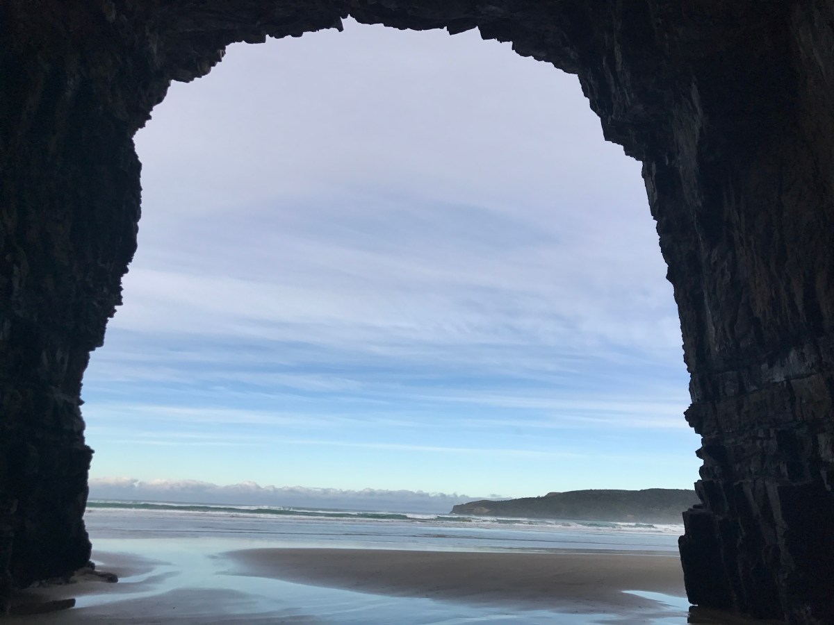
Sunday morning I started by backtracking about 35 KM (about 22 miles) on twisty roads to a special location, Cathedral Caves. Cathedral Caves can only be accessed within an hour on both sides of low tide and even then only during daylight hours – so you have to consult the schedule and plan accordingly – and I was lucky – there are entire spans of days that you cannot access them at all. There is a slight hike down to get to the beach, and an access fee (make sure you have cash – there were some young girls that had to go try and find an ATM) for the trail – but at 5.00 NZD it is worth it for the trail to be maintained by the local land owners.

IMG_6304

After the 1.5 km walk downhill through some beautiful bush,

You emerge onto the beach – a peaceful, untouched beach oasis.

After walking down the beach – you arrive at the caves, and WOW!

This slideshow requires JavaScript.

They were massive – and it was so incredible to see the changes to the caves by the sea water continually beating against the rocks. It was amazing.

After I had thoroughly explored the caves, I trekked back across the beach, and up the trail to my car.

My next stop highlights the Kiwi sense of humor. You will recall that yesterday I visited Purakanui Falls and McLean Falls, both beautiful examples of waterfalls, right?

Well, behold the New Zealand “Niagra Falls”

Next I ventured south – to Slope Point – the furthest south point of the South Island – which is located on a sheep farm (no joke, you cross through the pasture to get to the marker). The access is closed during Lambing season (September – November)

My next stop was the cliffs at Fortrose. It was windy – so I didn’t stay long, or get too close to the edge, but it was cool.

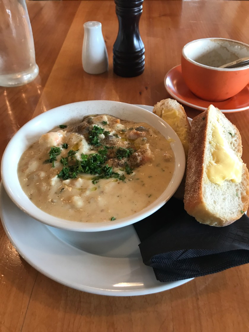
A bit chilly at this point, I was thankful to find a cafe and grab some Seafood Chowder and a hot coffee before continuing my adventure.

IMG_6392

Next up, I made my way to Bluff, and Stirling Point, which is often confused with Slope Point – Stirling Point is the end of the Motorway which stretches from the tip of the north island (at Cape Reinga) to here in Bluff.

This slideshow requires JavaScript.

With some extra time before I needed to be in Invercargill and return my rental car, I decided to explore more of Bluff. This led me to follow signs to the Te Rau Aroha Marae. Such a unique Marae from the outside – beautiful!

Then I headed to the Bluff Lookout, thinking it might be a cool spot to enjoy the sunset.


As I headed up the path to the lookout, there were some informative signs about Moas, birds and other native wildlife, predators, pests and history.

It was a good call to head up here!

Check out the views!

Check out this panorama of the views:

https://occipital.com/360/embed.js?pano=5mSJpq&width=640&height=480

Finally, I headed to Invercargill, hit the grocery store, returned the rental car, did laundry and prepared for my next journey – I am off to Raikura – Stewart Island in the morning.

Advertisement

A day in Picton – a tramp to Bob’s Bay, Ships Cove, Dolphins and delivering mail by boat.

I got up the morning to a beautiful sunshiny day. I got dressed and headed next door to the famous Picton Village Bakkerij (filled with Dutch treats), which I just knew I had to visit in honor of my friend Simone. I grabbed a coffee, a breakfast pie, a vegetable cheese bread for lunch and a dessert treat before heading on my way. I had no plan for the morning, and only had to be back to the harbor to catch my Mail Cruise by 1:15.

I decided I would follow one of the shorter “tramping” trails and venture out to Bob’s Bay. It proved to be a great choice!

I started by walking across the harbor and across the harbor bridge, then set out along the opposite side of the harbor for the start of the trail. I was amazed by some of the boats in the harbor – there were “boats” with boats on them – actually yachts with smaller yachts in some cases.

Once at the trail, I was faced with a choice, the high route of the low route. Both were said to take about 30 minutes, but the low route came with a disclaimer about not being good for kids due to bluffs and cliffs – which translated to me as great views, so I went with the lower. It was beautiful, but they were not kidding about being right by the cliffs – I would not want to be walking with a child on that path – thus the warnings – I even made a stop to grab a trusty hiking stick for myself, just in case. . Still – the views made it clear that I made the right choice – while I enjoy tramping through the bush – the sea views on this trail were amazing.

The trail was quick, and not terribly difficult, and I made it to Bob’s Bay, where I was rewarded with a beach to myself for quite sometime – I sat, enjoyed my picnic lunch and just enjoyed watching the various boats, ferries, kayaks and other vessels pass by as the waves lapped on the shore.

This slideshow requires JavaScript.

Once my alarm went off to go back for my next activity, I headed back on the trail, and crossed back over the bridge to check in for my next adventure, a ride on the Mail Boat through Queen Charlotte Sound. At this point the clouds had taken over a bit, and the sky was spitting rain, but hey – whats a little bit of rain on the sea, right?

We departed on time, and our guide was a stitch – he had funny stories about the area, about his mail delivery experiences, and the local history. I started at the top of the boat for the view, but as we were heading out into the coves rather fast, got chilly and went downstairs for a bit, returning to the top at key points to see birds, dolphins and great scenery. Check out these Hector’s Dolphins we saw:


Hector’s Dolphins are small (only about 1 meter) and found only in New Zealand – they are also highly endangered.

Once the mail delivery started, it was less fast and windy, so I spent more time up at the top, just savoring the view of this beautiful part of the world.

For some perspective, and so you can see the lay of the land, here is a screen shot of the area we cruised through.

IMG_3177

About 1/2 way through the cruise, we journeyed to Ship’s Cove, most famous for being a landing area and refuge for one Captain Cook. We were able to get off the boat here, and learn a little about the history of this area before continuing on our journey.

We delivered more mail, then headed back to Picton.

At this point it was quite wet and chilly, so I decided that I would go grab dinner before going back to the hostel, and what better to warm me up that some Irish Stew at the pub – while it was March 18th for me – it was still (sort-of) March 17th in the states, so I just celebrated a bit late here.

IMG_3281

Tomorrow is Sunday, and I get to journey to Nelson for my exciting week of school visits. I have a few hours before my bus departs in the afternoon, so who knows what fun I will find before I head out.